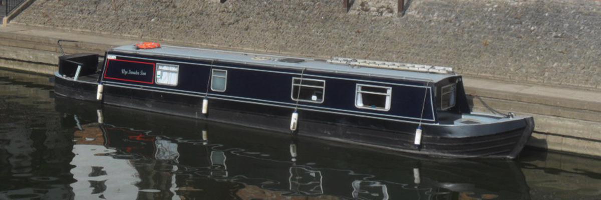
Sharpness to Portishead & return
Planning for a 2 day voyage Sharpness to Portishead and return.
Weather forecast for the 2 days, 2nd & 3rd June 2018.
Saturday - Sharpness High water 1055 Hours, Depart Sharpness at 1025 Hours. Weather Fine, no rain forecast. Wind 3 to 4 from South West, 7 to 16 knots.
Sunday return, Lock out 0700 Hours, clear Lock at 0715 Hours. Weather Fine, no rain, low cloud, Wind 3 to 4 from East by North East clearing by mid morning.
Book the bridge for access to Sharpness Docks and Sea Lock for 0900 Hours, 2 hours before high water (24 hours advance notification required)
Saturday 0900 Hours. We have moved from the mooring to just outside the Dock access Bridge, the Bridge is opened.
0920 Hours. Move into the Lock and then Lock down and move to the Port side pontoon to wait for high water at 1055 hours.
1000 hours. Check oil levels in the engine and gearbox and coolant, all O K. Radio Sharpness for radio check on channel 13.
As the last lock up in Portishead is 1415 Hours. I decided to leave at 1025 Hours, we were against the tide for the first mile to Berkeley Power Station and we should gain about 20 minutes or so covering the 21 miles to Portishead by being downstream of Sharpness when the tide changes.
Last summer, on a return from Portishead in the early morning we had a problem with sudden fog (sea mist) just downstream of the New Severn Bridge, we had an Apple iPhone on board with a GPS app and this fixed our position, the fog cleared and we were exactly where the iPhone GPS had given our position. Over the winter I acquired a Cellular iPad Mini with a GPS facility and OpenSeaMap for my laptop, a free online nautical chart and also a file conversion utility KML2GPX that converts KML files to GPX files suitable for use with MotionX GPS HD on the iPad, this then allows me to work out a course on my laptop and then transfer it to the iPad to use on Wye Invader Two, this we intended to try out over the next 2 days.
An iPad (or similar) although very accurate, should not be considered a primary navigation device. When trip planning such as the Tidal River Severn, Wye Invader Two uses Marine charts, a skipper with Maritime qualifications to navigate such waters and who has many years marine experience including navigating the Tidal River Severn many times in a variety of weather conditions in both a 124 foot Dutch Barge and a 40 foot Narrowboat.
1025 hours, we depart Sharpness and turn into the tide towards Berkeley Power Station about 1 mile ahead, 1100 hours we are now just short of Berkeley Power Station, the first Channel marker on the Port side and the first Waypoint on the iPad. We are now on the top of the tide, we have slack water for about 15 minutes then the tide starts to pick up speed as it ebbs.
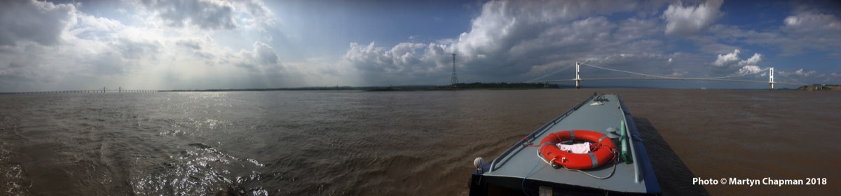
1145 hours, Wye Invader Two is about 1 mile short of the second Power Station and the Old Severn Bridge, we have to turn Starboard across the River Severn to the Chepstow side, the waves are now breaking on the port bow from the South West, as we get closer to the Chepstow side the waves get smaller and the Old Severn Bridge gives some shelter.
The 3 miles between the Bridges are calm and sheltered by the 2 Bridges. At 1245 hours we pass under the New Severn Bridge and on for the next 6 miles to Avonmouth, we then follow the Starboard (Green) channel markers to Portishead, the river being deeper and wider the Wind over Tide is not as noticeable and the Lock gate is kept open.
0920 Hours. Move into the Lock and then Lock down and move to the Port side pontoon to wait for high water at 1055 hours.
1000 hours. Check oil levels in the engine and gearbox and coolant, all O K. Radio Sharpness for radio check on channel 13.
As the last lock up in Portishead is 1415 Hours. I decided to leave at 1025 Hours, we were against the tide for the first mile to Berkeley Power Station and we should gain about 20 minutes or so covering the 21 miles to Portishead by being downstream of Sharpness when the tide changes.
Last summer, on a return from Portishead in the early morning we had a problem with sudden fog (sea mist) just downstream of the New Severn Bridge, we had an Apple iPhone on board with a GPS app and this fixed our position, the fog cleared and we were exactly where the iPhone GPS had given our position. Over the winter I acquired a Cellular iPad Mini with a GPS facility and OpenSeaMap for my laptop, a free online nautical chart and also a file conversion utility KML2GPX that converts KML files to GPX files suitable for use with MotionX GPS HD on the iPad, this then allows me to work out a course on my laptop and then transfer it to the iPad to use on Wye Invader Two, this we intended to try out over the next 2 days.
An iPad (or similar) although very accurate, should not be considered a primary navigation device. When trip planning such as the Tidal River Severn, Wye Invader Two uses Marine charts, a skipper with Maritime qualifications to navigate such waters and who has many years marine experience including navigating the Tidal River Severn many times in a variety of weather conditions in both a 124 foot Dutch Barge and a 40 foot Narrowboat.
1025 hours, we depart Sharpness and turn into the tide towards Berkeley Power Station about 1 mile ahead, 1100 hours we are now just short of Berkeley Power Station, the first Channel marker on the Port side and the first Waypoint on the iPad. We are now on the top of the tide, we have slack water for about 15 minutes then the tide starts to pick up speed as it ebbs.
1145 hours, Wye Invader Two is about 1 mile short of the second Power Station and the Old Severn Bridge, we have to turn Starboard across the River Severn to the Chepstow side, the waves are now breaking on the port bow from the South West, as we get closer to the Chepstow side the waves get smaller and the Old Severn Bridge gives some shelter.
The 3 miles between the Bridges are calm and sheltered by the 2 Bridges. At 1245 hours we pass under the New Severn Bridge and on for the next 6 miles to Avonmouth, we then follow the Starboard (Green) channel markers to Portishead, the river being deeper and wider the Wind over Tide is not as noticeable and the Lock gate is kept open.
Return to Sharpness.
The first Lock down is at 0700 Hours, the Lock is open from 0630 Hours and uses Red and Green ‘Traffic lights’.
0640 Hours. We start Wye Invader Two and move into the Lock on a green light, secure to the floating pontoons and wait for Lock down.
0700 Hours. Lock down, 0710 Hours - the gates open, we start the engine and move out of the Lock and clear Portishead pier by 0715 Hours.
As you move at a right angle to cross the Main River Navigation channel into Avonmouth Docks, about half way across you can see and feel the tidal current as Wye Invader Two is pushed sideways and we enter the mainstream River Tidal Channel.
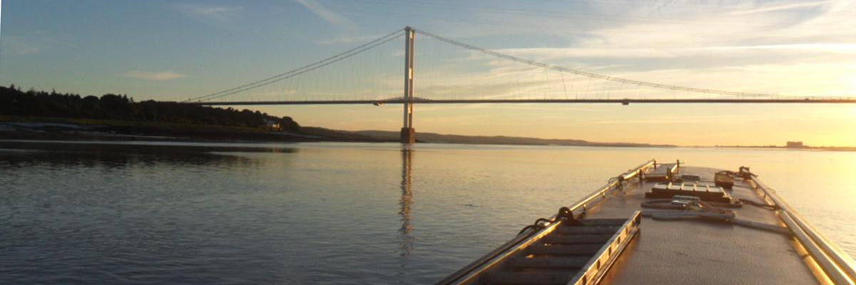
We pass under the New Severn Bridge 35 minutes after leaving Portishead, then under the Old Severn Bridge at 0816 Hours at an average speed of 11 knots. We clear the Old Severn Bridge, the sun is warm and Sharpness can be seen about 8 miles ahead, we have to slow down as we still have an hour and 30 minutes before the Lock is open. All the Navigation Channel Markers are clear and easily picked out with binoculars, my iPad with MotionX GPS HD also has each Channel marker shown to the side of the Waypoint.
0925 Hours. I give Sharpness a radio check on VHF Channel 13, they respond and tell us to go into the Sea Lock and moor to the pontoon and wait as they are opening the bridges to give access to the Dock and Lock for some boats to Lock down.
1000 Hours. We are the last into the lock, by 1030 Hours we are moored by the water point on the Canal washing Wye Invader down before we moor up in the Marina and have a coffee.
The first Lock down is at 0700 Hours, the Lock is open from 0630 Hours and uses Red and Green ‘Traffic lights’.
0640 Hours. We start Wye Invader Two and move into the Lock on a green light, secure to the floating pontoons and wait for Lock down.
0700 Hours. Lock down, 0710 Hours - the gates open, we start the engine and move out of the Lock and clear Portishead pier by 0715 Hours.
As you move at a right angle to cross the Main River Navigation channel into Avonmouth Docks, about half way across you can see and feel the tidal current as Wye Invader Two is pushed sideways and we enter the mainstream River Tidal Channel.
We pass under the New Severn Bridge 35 minutes after leaving Portishead, then under the Old Severn Bridge at 0816 Hours at an average speed of 11 knots. We clear the Old Severn Bridge, the sun is warm and Sharpness can be seen about 8 miles ahead, we have to slow down as we still have an hour and 30 minutes before the Lock is open. All the Navigation Channel Markers are clear and easily picked out with binoculars, my iPad with MotionX GPS HD also has each Channel marker shown to the side of the Waypoint.
0925 Hours. I give Sharpness a radio check on VHF Channel 13, they respond and tell us to go into the Sea Lock and moor to the pontoon and wait as they are opening the bridges to give access to the Dock and Lock for some boats to Lock down.
1000 Hours. We are the last into the lock, by 1030 Hours we are moored by the water point on the Canal washing Wye Invader down before we moor up in the Marina and have a coffee.